Cooler Weather Moving into Middle Georgia
MACON, Georgia. (41NBC/WMGT) – After a wet work week, drier conditions will return to Middle Georgia this weekend as temperatures cool down as well.
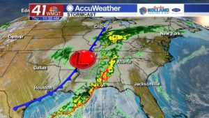
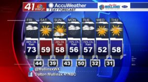
Friday is going to be a lot like yesterday; mild temperatures with on and off scattered rain showers. High temperatures ahead of a cold front that will be passing through our area today will soar into the low 70’s while overnight low temperatures will plunge into the low to mid 40’s.
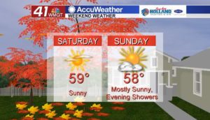
Weekend looks cool and dry.
After seeing afternoon temperatures top out in the 60’s and 70’s over the past five days, cooler air works its way into Middle Georgia behind the cold front. Saturday and Sunday high temperatures will stay in the mid to upper 50’s while low temperatures will bottom out in the upper 30’s on Sunday morning. The weekend will be rain free until another weather disturbance moves into our area overnight Sunday night into Monday morning.
Split week next week.
Monday and Tuesday are looking like wet days across the area as another cold front moves through Middle Georgia on Tuesday. Behind this cold front is arctic air that will usher in overnight low temperatures in the low 30’s for Tuesday and Wednesday nights. I do expect some areas to see temperatures in the upper 20’s. This could potentially be our first frost of the year so you will want to bring in sensitive plants. After a wet start to the week, Wednesday through Friday will be rain-free as an area of high pressure builds in.
Connect with Meteorologist Dalton Mullinax on Facebook and Twitter (@MullinaxWX) for weather updates throughout the day. You can also watch his forecasts Monday through Friday on 41NBC News at Daybreak (5-7 a.m.) and 41Today (11 a.m.).