Wet Week Ahead for Middle Georgia
MACON, Georgia. (41NBC/WMGT) – After a dry weekend, rain will return today ahead of another cold front that could bring the chance for strong to severe storms.
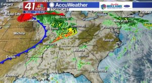
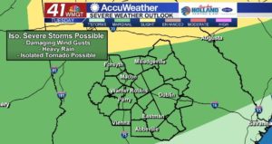
After seeing one cold front move through Middle Georgia late last week, another front is going to move through over the next twenty-four hours. Like last week, this front brings the potential for strong to possibly severe storms to our area overnight Monday night into early Tuesday morning. The main threats are gusty winds, localized heavy rainfall, and an isolated chance of a weak spin-up tornado. While the tornado threat is low, it is not zero so you want to make sure you have a way to get severe weather warnings, whether that be by watching 41NBC News on TV, downloading the FREE 41AccuWeather app to your mobile devices or purchasing/turning on a NOAA Weather Radio.
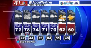
Once the front passes through tomorrow morning then we will begin a temporary drying period that will last for less than twenty-four hours. Rain will return Wednesday afternoon and showers will continue on-and-off into Friday.
Weekend looks cool and dry.
After a wet work week, I do expect that our weekend will be dry with high temperatures in the low to mid 60’s. It is going to feel a-lot like Fall as overnight temperatures dip into the low 40’s with a few upper 30’s mixed in. Cooler air will continue to feed into our area early into next week.
Connect with Meteorologist Dalton Mullinax on Facebook and Twitter (@MullinaxWX) for weather updates throughout the day. You can also watch his forecasts Monday through Friday on 41NBC News at Daybreak (5-7 a.m.) and 41Today (11 a.m.).